
Living in the Bocage Landscape
We believe that sustainability is about learning to live at peace with our environment. To do this, we must understand the identities of the local landscapes and ecosystems, and appreciate their unique features so they may play a defining role in people’s daily lives.

| Location: | Denderleeuw, Belgium |
|---|---|
| Status: | Competition Finalist |
| Date: | 2021-2022 |
| With: | Metapolis, Traject, IDEA Consult |
We believe that sustainability is about learning to live at peace with our environment. To do this, we must understand the identities of the local landscapes and ecosystems, and appreciate their unique features so they may play a defining role in people’s daily lives.
Our proposal, “Living in the Bocage Landscape” creates a neighbourhood of 320 new homes that aims to channel the local landscape identities of the bocage, with its patchwork of agricultural fields, arbors and hedgerows, to structure appropriate urban densification, fostering community building, healthy living, economic growth, and increased biodiversity.
We believe the site can not only be a pleasant living environment for humans, but also a qualitative habitat for all kinds of animals. The Natura2000 zone shows that very high-quality nature on a limited surface is possible here.
We want to form a stepping stone in an ecological corridor through built-up and undeveloped areas, where all kinds of species can migrate to the newly created nature areas (toads and salamanders in the wet areas, bees and insects in the flower meadows and orchards, bats and bird species in the trees).
To successfully develop the project with local expertise, especially during COVID times, we formed a team of like-minded local designers and consultants that include Metapolis as well as Mobility consultant Traject, and sustainable development and Real Estate consultant IDEA Consult.

The Site in Context
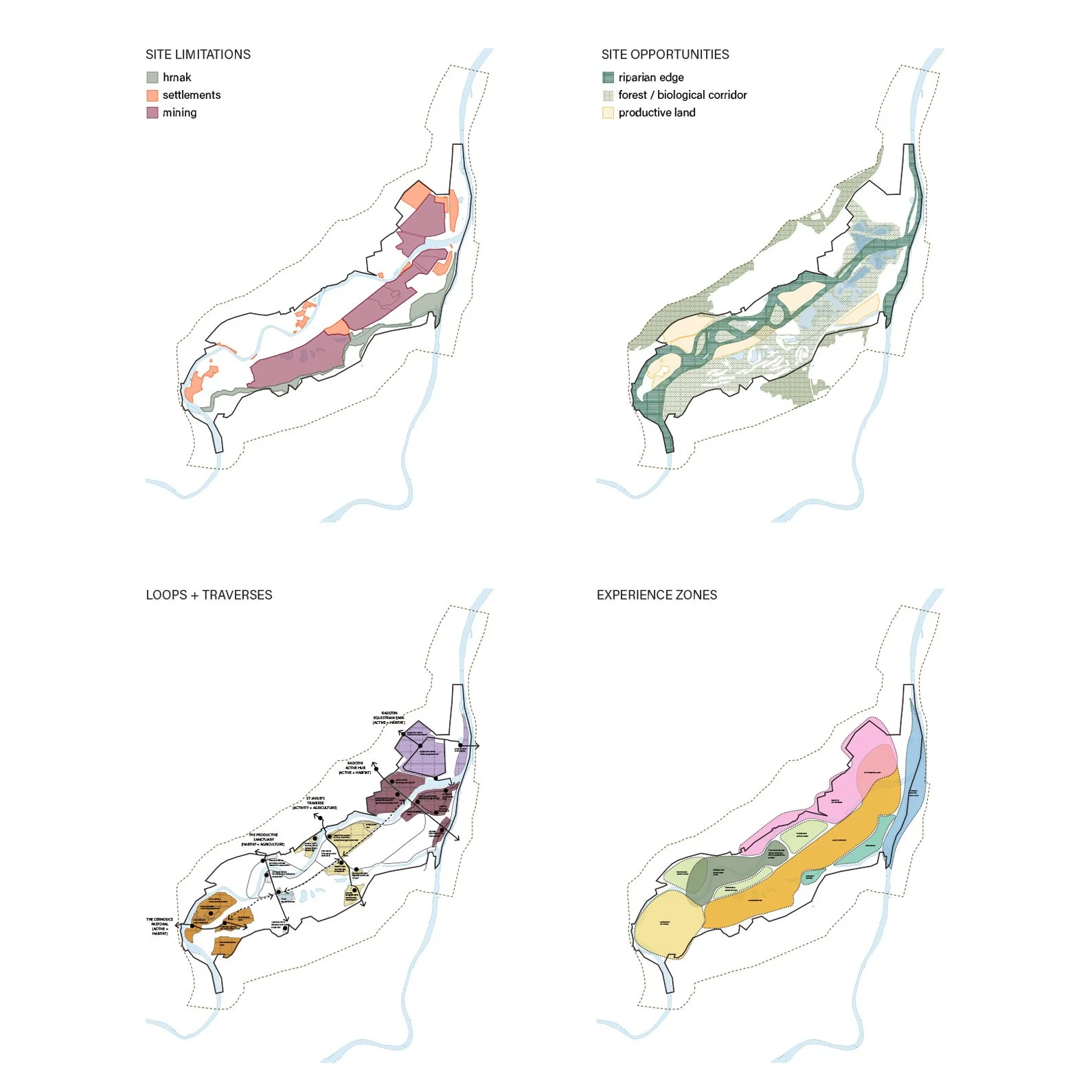
Denderleeuw is situated in between two large-scale open space structures:
In the west a vast agricultural area structured by a number of streams such as Molenbeek or Wildebeek that flow into the Dender, acting as a network of ecological corridor composed of swamp forests and poplar groves.
In the east is a lower flood-prone valley composed of marshy meadows, numerous water bodies and dense forests.
The site itself is a triangular zone of bocage (fields bound by ecologically-rich buffers), defined by residential streets (“ribbon” development) to the North and West, and by railroad tract to the East. The core of the site is prone to flooding.
There are only three access points into the site, one from the North, one from the Northeast, and one from the Southwest. Each creates different opportunities to connect the new neighbourhood to Denderleeuw’s pedestrian and vehicular networks. The North access point is a key connection point between the nearby sports facilities and the core of the new development site. On the other hand, the Southwest connection point leads directly to the promising, but currently underused urban node of Iddergem with shops, a school and a church.
The Masterplan
We believe that the following composition of spaces can promote social cohesion in the neighbourhood, with various spaces fostering diverse interactions: Around the communal lawn you are in close contact with your closest neighbours, the front gardens on the street side facilitate conversation with the neighbours across the street, etc…
The masterplan is structured around four types of spaces:
A central neighborhood park that takes the potentially flood-prone area and the latent power of the canal as a starting point. Neighborhood gardens overflow into it. Together with trees and water, they form a reinterpretation of the bocage landscape.
The outer ring is a productive edge, with denser forestation alluding to the swamp forests of the region's typical meersen. It also acts as a buffer against the noise of the railway and a view through the backyards of the local residents. A number of existing parks, groves and plots with an ambiguous status are also included. The denser green border acts as a biodiverse green zone, a suitable habitat for animals and insects. In this productive edge fields mingle with vegetable gardens, orchards and parking bays and habitat nodes.
Between the productive edge and the open park landscape, we organize the housing as a series of residential courtyards giving out on the central park. U-shaped groups of buildings with an alternating code of strips of terraced houses and park villas around a communal green zone, with back gardens that continue into the shared courtyard.
On the other side of the courtyard, the houses along residential streets, a kind of car-free residential areas where the car can drive but is not allowed to park, so that the street becomes a social and child-friendly place.
Rows of trees, water features and soft paths run through these different parts of the master plan and connect them with each other.

The site is designed as a series of overlapping ecological and healthy living systems: water management, biodiversity, production landscapes and transportation

Walkable multi-generational communities integrated within the landscape

Productive gardens build communities around the values of healthy living and sharing

The bocage landscape acts as a rich biodiverse space and water management system

Various flexible housing typologies help create a demographically diverse neighbourhood (apartments, small houses, co-housing, assisted living, etc…)

Namdo History Museum
Toronto-based Office Ou has been selected as a finalist for the design of the Namdo History Museum.

| Location: | Namdo, South Korea |
|---|---|
| Status: | Competition Finalist |
| Date: | 2022 | With: | HLD Landscape, SAC |

The Namdo Righteous Army History Museum will commemorate the civilian militias who, throughout Korean history, volunteered to stand up to protect their land when it was under threat. They were the grassroots of Korean society, ordinary working class people including peasants, butchers and other labourers.
The museum is to be located on a heavily damaged hill, the site of a soon to be decommissioned historical recreation complex used for movies and TV shows. With our project, we ask: how can we memorialize the Righteous Armies while learning from their history to address contemporary challenges which are now largely social and ecological? What does it mean to protect the land and stand up for justice? How can an integrated landscape and architecture project both practice and memorialize the fundamental ethos of the Righteous Armies?
Site design matrix
Embody the Spirit of the Righteous Army
In order to embody the spirit of the Jeollanam-do Righteous Armies, the museum park must reflect the unique, historical nature of ordinary people taking up arms to protect their country. It must combine the diverse layers that made up the lives of Righteous Army members, and symbolically embody the transformative nature of their historic actions.
The project combines three layers of life on one site: the fighting life of the Jeollanam-do Righteous Armies, the everyday life of Jeollanam-do peasants, butchers, soldiers, and scholars who became Righteous Army soldiers, and the lives of diverse contemporary visitors to the site who will come here to learn, think, and rest. These three layers haveunique purposes, landscapes, temporalities, and design languages.
Fighting Life
The purpose of the fighting life is to stand up to invaders. Its landscapes are mountain encampments, hideouts, and battlefields. Its time-scale is centuries of history. It is embodied in the design language of rugged rock-like figures jutting out of the mountain terrain, as if the hills of Jeollanam-do are themselves rebelling against invaders.
Ordinary Life
The purpose of ordinary life is to take care of the land and its people. Its landscapes are villages, farms, and orchards. Its time-scale is that of the seasons. It is embodied in the intervention of ecological restoration, soil stabilization, reforestation, and re-introduction of productive landscapes on an ecologically damaged site.
Life of a Visitor
The purpose of contemporary visitors is to learn, reflect, and take a break from their daily routine. Their landscape is a memorial park. Their time-scale is that of a short visit. The design intervention for them is the accessible paths through the site, as well as visitor facilities and parking.

The design evolves through following steps:
First, the terrain is restored to a stable and healthy condition and the existing ecosystem is strengthened. Tending to the wellbeing of the land and all of its multispecies inhabitants is itself an act of land protection. This recreates two zones which were historically on the site: the forest and the fields.
Second, the landscape is differentiated into several zones: arrival zone by the Sa-am Reservoir; wetlands; fields growing crops for crafts; village; agricultural area; and finally the museum in the forest. Each landscape is guarded by rugged masonry monuments that memorialize the members of the Righteous Armies.
Third, these zones are inhabited with life. This requires their subdivision into plots, and addition of necessary infrastructure to support the activities of each. The life of the site should reflect the diversity of the ordinary lives of the Righteous Army members.
Finally, a series of pathways for visitors is added, with a main, accessible pathway that meanders through all zones. The museum park commemorating the Righteous Armies should be accessible to everyone.

Slope Restoration
The construction of Naju Image Theme Park has damaged the landscape of the site, creating erosion risks, cutting back its forests, and erasing its historic agricultural fields. The memorial park of Jeollanam-do Righteous Army Museum must have regenerative properties, creating landscapes and buildings that become integral and beneficial parts of the local ecosystems and the local cultural identity.
The project recreates gentle slopes in strategic portions of the site through an on-site cut and fill process, and creates terraces that support slope stability necessary for ecological revitalization. These interventions protect the hill and help manage water runoffs to reduce erosion.
Forest Rehabilitation
The forest around the Naju Theme Park ends at an abrupt edge. This limits the wildlife movement across the site, reducing its value as a habitat. Revitalizing the ecology of the site requires restoration of a healthy forest edge.
The project expands the forest into the site. It creates a healthy forest edge by gradually transitioning from an evergreen pine forest, to deciduous tree species, and finally lower shrubs. The length of the forest edge is significantly increased by extending "fingers" of forest into the site. The length of the transition zone, and its gradual nature maximizes habitat range and ecological complexity of the site.
Inviting Local Communities
Righteous Armies came from diverse backgrounds. They were farmers, soldiers,butchers, craftsmen, and scholars. Inviting local communities to inhabit the park embodies the spirit of the Righteous Armies in two ways: by recreating through the diversity of users of the site the diverse membership of Righteous Armies, and by fostering a connection to the local community much like the Righteous Armies experienced.
In addition to the Museum program, the park creates zones dedicated for crafts, food production, research, and art. By diversifying its stakeholder base, the park will be used beyond Museum hours, and will become an integral part of the local community.

Slope restoration, forest rehabilitation and inviting local communities

Morning cotton harvest in the fields. Visitors are immersed in an ancestral, productive landscape, allowing them to consider the Righteous Armies in the context of everyday life. Rice, indigo, cotton, and hemp fields can be rented out by local farmers. Productive life is brought back to the site.

In Times of Peace: A Fall Day in the Village. The site houses an artist residency for people in different fields. Craftsmen, using traditional materials grown on site, as well as artists and scholars can stay at the local hostel and make use of the flexible village square, which serves as a space for performance and gatherings, as well as for seasonal agricultural events like drying of persimmons and processing of plum fruit.

Reaching the summit, visitors arrive at the museum as one would have reached a righteous army encampment in the forest, and on the mountain. Overlooking the Yeongsan river, the monuments come into clear view, each with a relationship to its surrounding landscape.
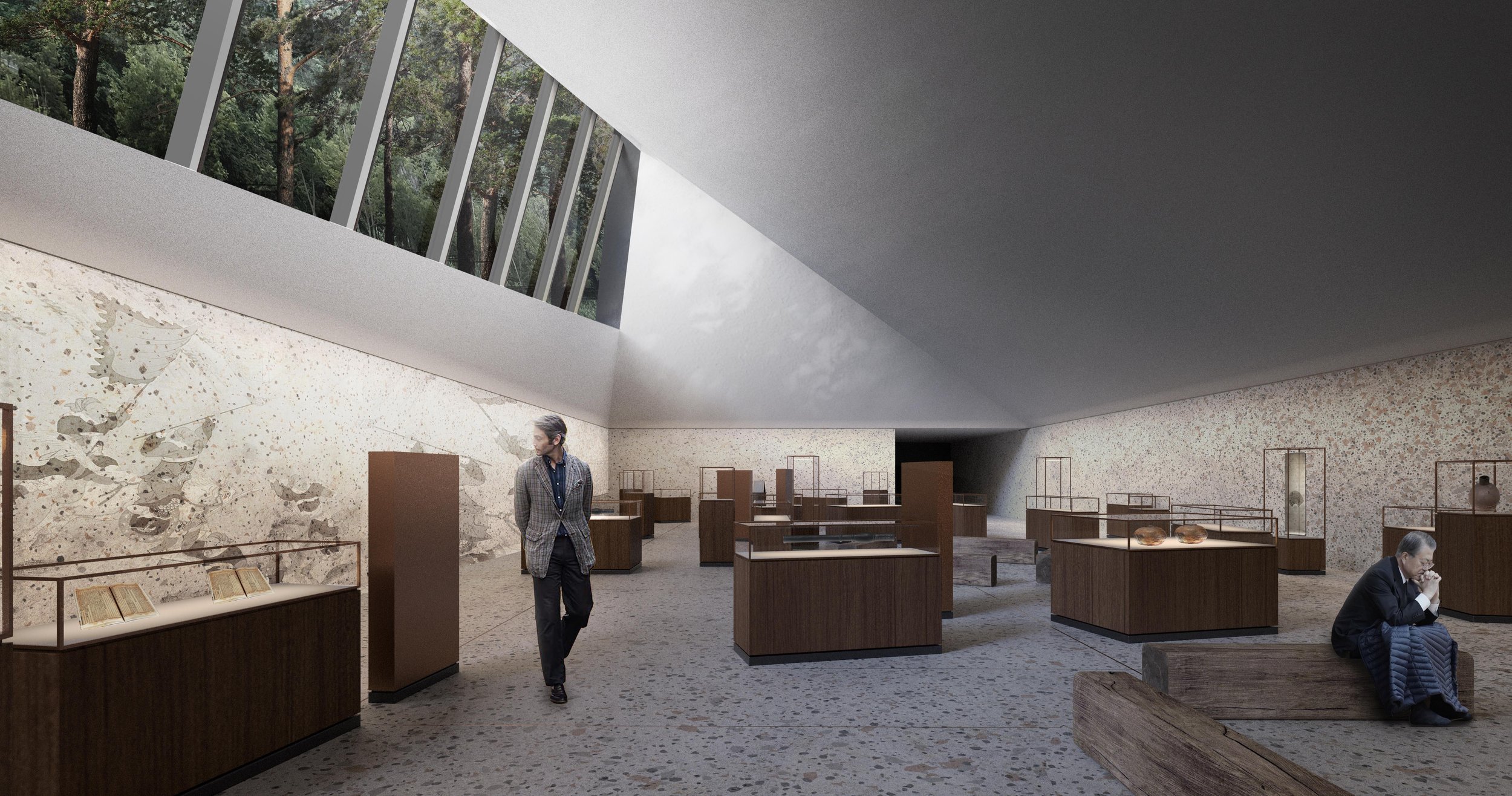
This exhibition space tells the story of the 1592-1598 lmjin War. The space is only open on one side, where a long clerestory window provides a view into the under canopy of the forest above. The exhibition is a continuation of the forest into the museum. There are as many soldiers as trees in the forest, many anonymous, but each with a story to tell. Personas are recreated through artifacts. Stories are told in clearings within the exhibition space.

Overlooking the Joellanam-do landscape, the story of local Righteous Armies can be told within their regional context.


Stará Boleslav School
A school that nurtures growth through diverse encounters.

| Location: | Stará Boleslav, Czechia |
|---|---|
| Status: | Competition Finalist |
| Date: | 2023 |
To cultivate the development of a whole person, a school should facilitate a diversity of interactions between people, places, ecologies, and things. These interactions exist at multiple scales: at a student’s desk, in the classroom, in communal spaces shared by a single grade/several grades/the whole tier/the entire school and in the world beyond it. The courtyard, at the heart of the school, is an assemblage where the whole diversity of the school comes together. Around this courtyard, programmatic spaces are organized in clusters (sports, food, performance, core and specialized classrooms)
The school is connected to the broader world far beyond the boundaries of its site. It provides opportunities to connect to social and ecological networks. Landscapes and public spaces that bring local ecosystems and community into the school are located along the perimeter (and roof) of the school.


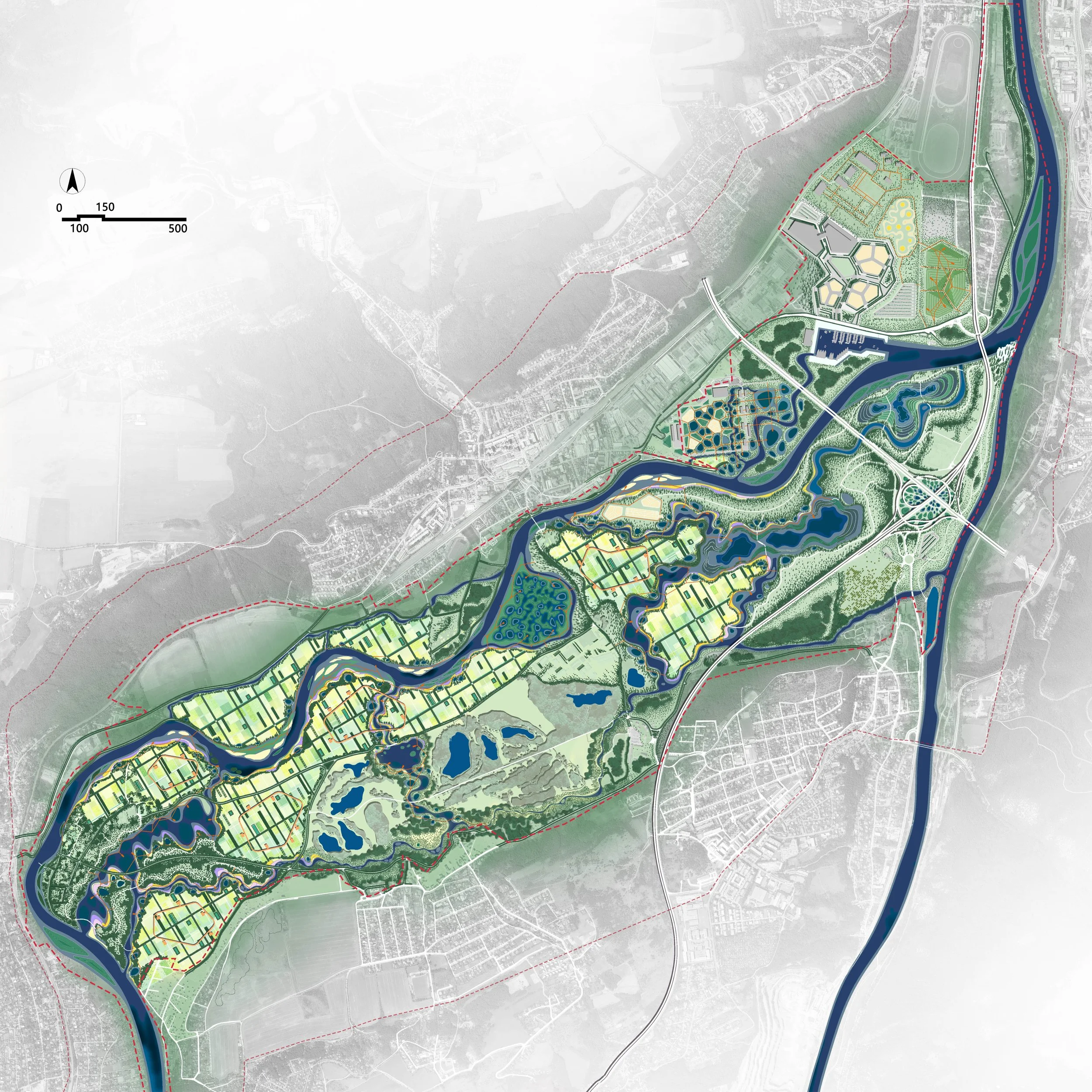
Soutok, A Productive "Sponge" Park
Suburban parks should have three functions: ecology, production and life.
In response to the challenges of frequent flooding and private ownership of land, the design proposes a new agricultural landscape model, which has three major benefits: ecological, economic and cultural.

| Location: | Czechia |
|---|---|
| Status: | Competition Finalist |
| Date: | 2022-2024 |
| With: | Turenscape / Yu Kongjian |
Suburban parks should have three functions: ecology, production and life.
In response to the challenges of frequent flooding and private ownership of land, the design proposes a new agricultural landscape model, which has three major benefits: ecological, economic and cultural.
For ecological benefits, ponds and wetlands are introduced to improve flood regulation and increase water storage capacity. When floods come, ponds can be used to receive more water, create different types of habitats, and increase local biodiversity.
For economic benefits, a variety of livelihood options are provided, in accordance with the current situation of land ownership. Gravel and sand excavated from the pits, that can become ponds, can be sold for economic profits. In the long term, the ponds can be used to raise fish and ducks or carry out water sports. The cultivated land can continue to be cultivated, or it can be used to breed livestock, plant fruit trees or operate homestays.
For cultural benefits, a recreation ring is implanted in the farmland to connect the slow rhythms of agricultural and hydrological systems with places for recreation, forming a diversified and vibrant recreation space. As a result, the existing farmland landscape on the site will gradually transition into a new agricultural model, which has both production functions and landscape recreation functions, and can regulate and store floodwaters and adapt to nature.
The above-mentioned principles of landscape change are implemented across the site. The existing golf course becomes a floodable area, and the mine pit is transformed into a large regulation pond, so as to form the final suburban park landscape according to local conditions. This is a suburban park with an ecological regulation capacity, a suburban production function and a place for cultural recreation, which will create a new model for European suburban landscape park.
The bold, neophilic character of the design reflects the character of the site itself: “a dynamic, and ever-changing, neophilic floodplain, and in it dynamic, ever-changing, neophilic suburbanization."


Jeju Island Jusangjeolli Living Heritage
Designed in collaboration with South Korean landscape architecture office HLD, this proposal was the runner-up in an invited competition to redesign the visitor experience at one of Jeju Island’s most characteristic natural heritage sites.
| Location: | Jeju Island, South Korea |
|---|---|
| Status: | Competition Runner-up |
| Date: | 2018 |
| With: | HLD Landscape |
Designed in collaboration with South Korean landscape architecture office HLD, this invited competition proposal tells the many-layered story of one of Jeju Island’s most important heritage sites, the Jusangjeolli columnar jointing area, where a forest of polygonal basalt columns formed when molten lava flowed into the sea and cooled under particular conditions. Through a mix of evocative landscaped zones, and a set of complimentary pavilions, the project reveals the history of the spectacular geological formations, the island’s volcanic origins, its pine forests and ancient mythology, local fishing traditions and agricultural practices, recent scientific research, and the impact tourism culture.
Vistors to the park would move through a series of highly evocative landscapes. Fields of volcanic gravel related to the area’s famous dry-stone windbreak walls. Agricultural areas, planted in resilient native species of coastal meadow, would tell of the history of the islands agricultural practices and settlement patterns. In other areas, soil is scraped away to reveal the underlying volcanic clinker, displaying the flow of magma from a nearby volcanic cone. Near the coastline, where there is enough soil, the island’s characteristic pine trees are re-established. All these landscapes are supported by a set of complimentary pavilions, which offer places of rest and shelter, or exposure and adventure, infrastructure for practical use, and places to gather.


Viewing Platforms
Lightweight platforms made of stainless steel grating over rough clinker, and textured concrete on flatter ground, expand the experience of visitors right up to the edge of the basalt formations, and create opportunities to gather in groups as well as enjoy the view in solitude.


Cultural Experience Zone
Further inland, the relationship between the island’s geology and centuries of human inhabitation is revealed, in an partly sunken pavilion that provides a gather space for public talks and performances.


Geological Exploration Zone
At the site’s eastern gateway, a ranger pavilion with a rooftop lookout provides a base for park staff, sho will provide guided tours of the site’s more sensitive areas.


Wave Cove
Where the ocean waves meet a cove in the cliffs, they are focused into an impressive spray of water, which is further amplified by the polished concrete canopy of the wave cove. The experience here focuses on the lives of the Haenyeo, the women divers of Jeju Island, who dive without oxygen tank, well into their 80’s, to gather shellfish like abalone and urchins.


Neobaegii Market:
Over the years, the park has provided a space for local villagers to sell their crafts and produce. A set of market pavilions at the park entrance, in close proximity to the ticket and information stations, provide a permanent link between the villagers and the park. These pavilions are inspired by the informal market stalls found all over South Korea, providing lockable storage space, plumbing and electricity, and a lightweight roof.

The site pavilions are a cohesive family with a similar construction logic, but depending on the location will have different material character.
See the full competition panels:

Gukhoe Daero
| Location: | Seoul, South Korea |
|---|---|
| Status: | Competition 3rd Place |
| Date: | 2019 |

Gukhoe-daero park leads directly to the National Assembly Building; it should represent the future of healthy and resilient city building. A 21st century park must generate value on multiple levels, socially, environmentally and economically. It must address the future of cities in terms of ecological resilience, the needs of populations in terms of health, sustenance and recreation, and needs to be flexible and multi-functional from a productive point of view. A new linear park on Gukhoe-Daero can also help bring together disconnected urban communities, ecological areas and people.
What is the DNA of such a healthy city? We believe that it is composed of three “strands”, each associated with a type of space:
1) Productive spaces
2) Active space
3) Wild spaces
Only when these three strands are brought together can citizens live healthy, active lives.


A Family of Landscapes: LH Daejang Town Masterplan

| Location: | Daejang, South Korea |
|---|---|
| Status: | Honourable Mention, Competition 3rd Place |
| Date: | 2020 |
| With: | SAC International |
Bucheon-Daejang area, located within the greenbelt of Seoul, is surrounded by diverse landscapes. Mountains to the south. Agricultural fields to the north, Gulpo creek to its east (and several smaller creeks running through it): Landscapes define the experience of the site.
The new town should be conceived as an articulation of (rather than erasure of) existing landscape, securing and strengthening its ecological function and fostering the creation of human communities within it. Creating a city that enhances biodiversity, and ecological strength of the landscape, will also foster a new kind of resilient human community.
Our proposal creates a hierarchy of landscapes, ranging from big nature corridors that perform the most important ecological and hydrological functions, active corridors containing sports fields, schools, and urban agriculture, ecological neighbourhood streetscapes, which combine transportation and ecological infrastructure, to intimate communal courtyards and pocket spaces.
The scale of landscape relates to the scale of the human community. The big nature serves the entire Bucheon-Daejang town. Each active corridor serves one district. Ecological streets serve a neighbourhood, and courtyards are shared with one’s immediate neighbours.
At each scale/layer/level the landscapes perform an ecological and hydrological function, a productive function - providing food, clean air, energy and carbon sequestration, they provide a connection to nature. By foregrounding the ecological, productive, and natural processes, the project also fosters new kinds of connections between the people and creates new resilient communities.
As one traverses outward from the apartment unit, the unit of engagement expands from one’s family, then to a collection of families, neighbours, who share a courtyard, to an entire neighbourhood that is a collective of courtyards. Multiple neighbourhoods comprise a district, sharing an Active Corridor. Finally, the Big Nature corridors are shared by the entire community of Bucheon-Daejang.
The hierarchy of landscapes is akin to a biological family, with each layer setting the stage for the next. It marks a continuum and mirrors the passage of a human's journey into and with the world. The innermost section, the Courtyards, embodies a sense of intimacy, enclosure and safety like an embrace as if to provide a shelter for an infant to begin the early steps into the world. The neighbourhood is a familiar and safe world for a child. While active corridors at the heart of each district facilitate diverse activities for young adults. Finally, the forests and creeks in the big nature corridors are like a wise mature adult.
As the landscape expands and opens up its physical presence, it breathes energy into the human engagement with the world as individuals and as a community, first with one's family, then with a neighbourhood, a community, then the world.

“Family of Landscapes” concept diagram

Masterplan

Masterplan morphology diagrams

Active corridor

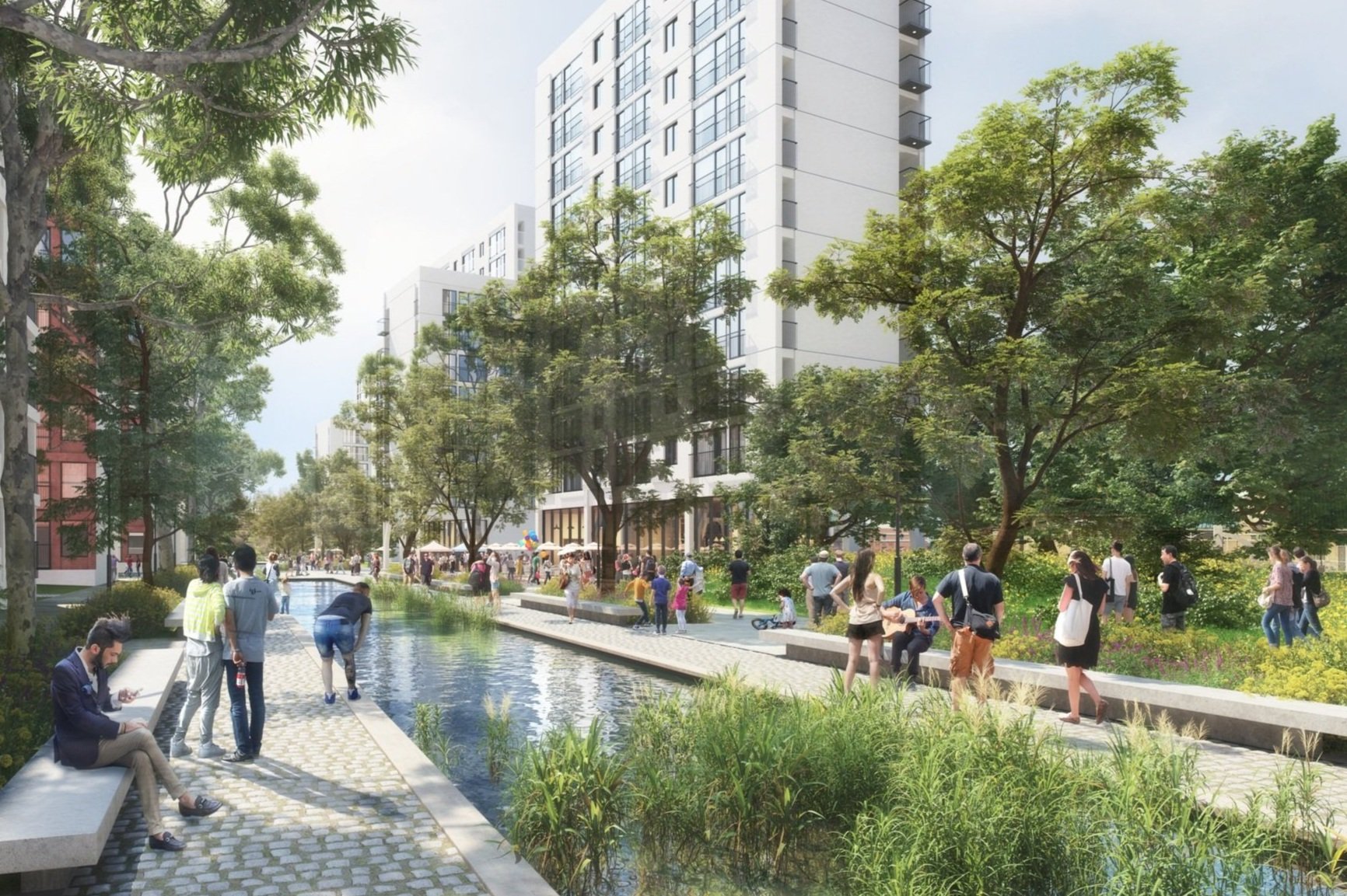
“Big Nature” Corridor at SBRT Node


Neighbourhood square in Pilot Village

Ecological promenade and commercial zone section

Ecological promenade and commercial zone plan

Ecological promenade and commercial zone View