New School of Jilovsko
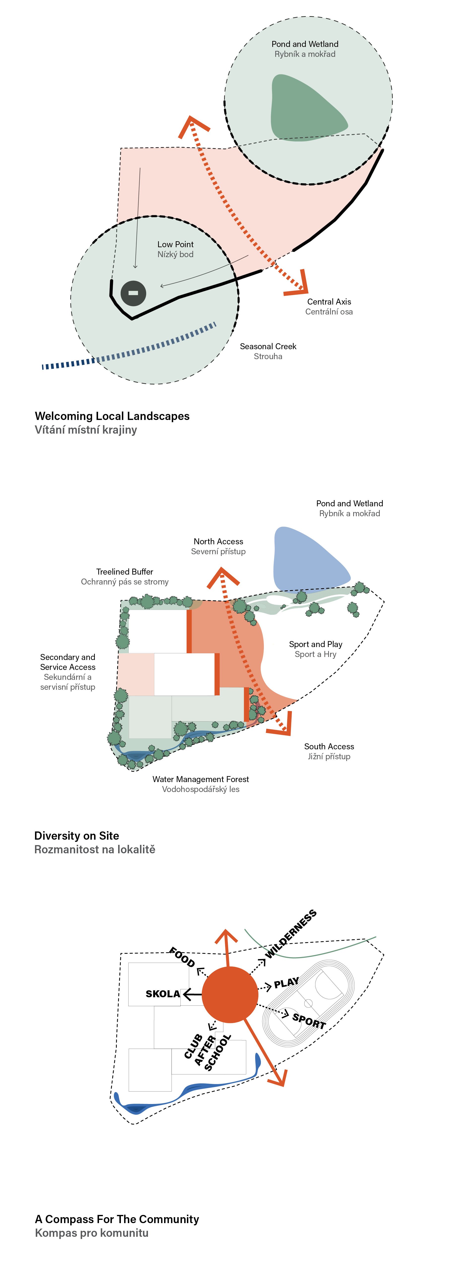
Discovering the richness of our immediate surroundings is the first step in learning about the world. The school is integrated into local ecology. Inviting the forest and natural water management into the site creates a diversity of landscapes.
The heart of the site becomes a node to explore this diversity: spaces to play, explore, exercise, gather, and learn. The school contains a variety of formal and informal, indoor and outdoor, spaces for learning organized around a shared commons.

Location: Jilovsko, Czechia
Status: Competition
Date: 2024
Discovering the richness of our immediate surroundings is the first step in learning about the world. The school is integrated into local ecology. Inviting the forest and natural water management into the site creates a diversity of landscapes. The heart of the site becomes a node to explore this diversity: spaces to play, explore, exercise, gather, and learn. The school contains a variety of formal and informal, indoor and outdoor, spaces for learning organized around a shared commons.
The School of Jílovsko will serve residents of five neighbouring municipalities. This amalgamation will foster new relationships, promote educational excellence, and ensure equal access to high-quality education for all residents. The school will become a central hub for learning and community activity. It will provide a platform for students, parents, and educators from different towns to come together, exchange ideas, and collaborate on educational initiatives. This inclusive approach will create a rich, dynamic, and diverse learning environment, enriching the educational experience beyond Jílovsko.
A central node for the community
The school is centrally located on a public path between important public spaces. The school must embrace its role as a central node that connects residents.
The school site is surrounded by diversity of landscapes: the fields, patches of forest, Sirotčí strouha seasonal creek, the pond, and the Radlík village itself. It is at a connection of two ecological axis - the seasona creek of Sirotčí strouha and the local pond network. The school should act as an ecological connector for the local ecosystem.
Welcoming Local Landscapes
While large portions of the local landscape are used for agriculture, there remain fairly diverse biotopes in the region, from mixed forests to grasslands and wetlands. These biotopes, mapped below (from nature.cz information) can inform the types of landscapes that can come to coexist on site with the school. Based on research and local data, there had been sightings of over one hundred different species within a 2 km radius of the site. These included plants, fungi, birds, amphibians, mammals, reptiles, insects and arachnids. These species predominantly dwelled within riparian, grassland and forest ecosystems. With the proper site and planting strategy, the site itself can become an important connector for wildlife networks and regional ecosystems, allowing children to become stewards of the local ecology.
The site should welcome local landscape typologies, becoming a connector for larger regional networks and habitats: grasslands and wetlands, forests, and productive landscapes.

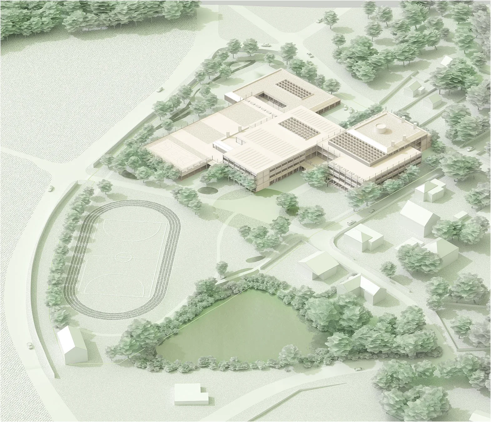


Four Units
The school is organized into four units. Each unit has a distinct programme, relationship to its context, morphology, height, and expression. Some units are taller than others. Some have accessible green roofs.
Unit 1 is tallest and contains all Tier II classrooms. Unit 2 is of middle height and contains all Tier I classrooms. Unit 3 contains pre-school and school administration. Unit 4 contains the gym.
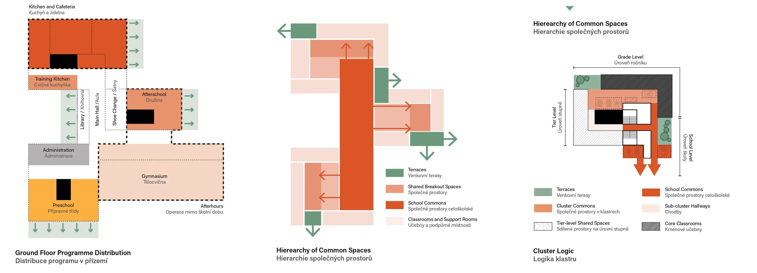
Ground Floor Programme Distribution
On the ground floor the program is distrubuted into different wings. Kitchen and Cafeteria is in Unit 1. Afterschool and Library in Unit 2. Unit 3 contains pre-school and school administration. Unit 4 contains the gym.
The wings of the ground floor connect to the main hall in the centre.
Hierarchy of Spaces
On a typical floor, the programme is organized hierarchically. An atrium shared by the entire school is in the centre of the floorplate. Smaller common spaces, shared by a cluster of classrooms are accessed off of the atrium. Classrooms and other rooms are accessed from these smaller common spaces. Each common space opens onto a terrace.
Each cluster of classrooms contains the following: core classrooms for two grades, specialized classrooms and other rooms shared by an entire tier, washrooms, common spaces, and an outdoor space.


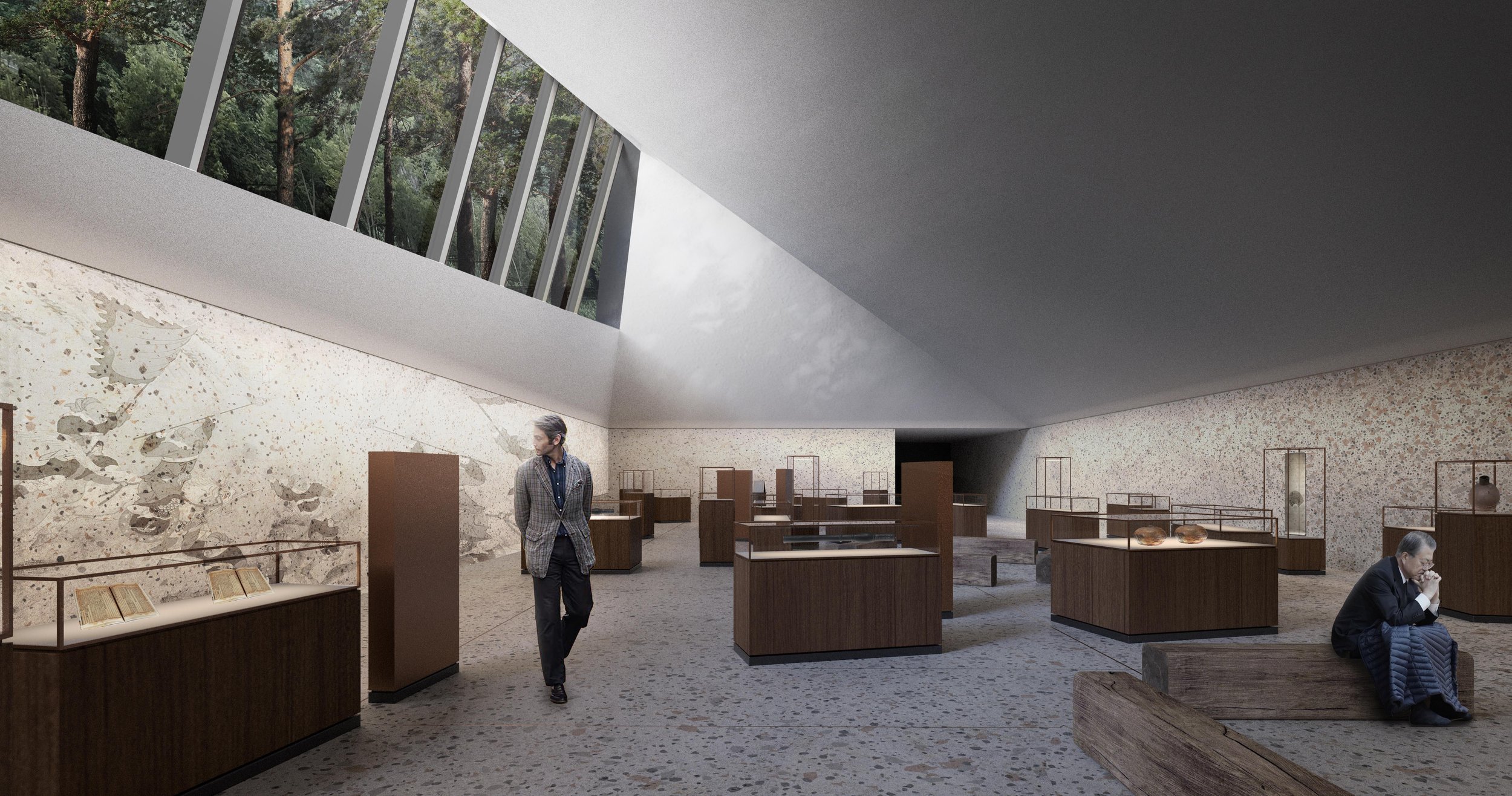
Namdo History Museum
Toronto-based Office Ou has been selected as a finalist for the design of the Namdo History Museum.

| Location: | Namdo, South Korea |
|---|---|
| Status: | Competition Finalist |
| Date: | 2022 | With: | HLD Landscape, SAC |

The Namdo Righteous Army History Museum will commemorate the civilian militias who, throughout Korean history, volunteered to stand up to protect their land when it was under threat. They were the grassroots of Korean society, ordinary working class people including peasants, butchers and other labourers.
The museum is to be located on a heavily damaged hill, the site of a soon to be decommissioned historical recreation complex used for movies and TV shows. With our project, we ask: how can we memorialize the Righteous Armies while learning from their history to address contemporary challenges which are now largely social and ecological? What does it mean to protect the land and stand up for justice? How can an integrated landscape and architecture project both practice and memorialize the fundamental ethos of the Righteous Armies?
Site design matrix
Embody the Spirit of the Righteous Army
In order to embody the spirit of the Jeollanam-do Righteous Armies, the museum park must reflect the unique, historical nature of ordinary people taking up arms to protect their country. It must combine the diverse layers that made up the lives of Righteous Army members, and symbolically embody the transformative nature of their historic actions.
The project combines three layers of life on one site: the fighting life of the Jeollanam-do Righteous Armies, the everyday life of Jeollanam-do peasants, butchers, soldiers, and scholars who became Righteous Army soldiers, and the lives of diverse contemporary visitors to the site who will come here to learn, think, and rest. These three layers haveunique purposes, landscapes, temporalities, and design languages.
Fighting Life
The purpose of the fighting life is to stand up to invaders. Its landscapes are mountain encampments, hideouts, and battlefields. Its time-scale is centuries of history. It is embodied in the design language of rugged rock-like figures jutting out of the mountain terrain, as if the hills of Jeollanam-do are themselves rebelling against invaders.
Ordinary Life
The purpose of ordinary life is to take care of the land and its people. Its landscapes are villages, farms, and orchards. Its time-scale is that of the seasons. It is embodied in the intervention of ecological restoration, soil stabilization, reforestation, and re-introduction of productive landscapes on an ecologically damaged site.
Life of a Visitor
The purpose of contemporary visitors is to learn, reflect, and take a break from their daily routine. Their landscape is a memorial park. Their time-scale is that of a short visit. The design intervention for them is the accessible paths through the site, as well as visitor facilities and parking.

The design evolves through following steps:
First, the terrain is restored to a stable and healthy condition and the existing ecosystem is strengthened. Tending to the wellbeing of the land and all of its multispecies inhabitants is itself an act of land protection. This recreates two zones which were historically on the site: the forest and the fields.
Second, the landscape is differentiated into several zones: arrival zone by the Sa-am Reservoir; wetlands; fields growing crops for crafts; village; agricultural area; and finally the museum in the forest. Each landscape is guarded by rugged masonry monuments that memorialize the members of the Righteous Armies.
Third, these zones are inhabited with life. This requires their subdivision into plots, and addition of necessary infrastructure to support the activities of each. The life of the site should reflect the diversity of the ordinary lives of the Righteous Army members.
Finally, a series of pathways for visitors is added, with a main, accessible pathway that meanders through all zones. The museum park commemorating the Righteous Armies should be accessible to everyone.

Slope Restoration
The construction of Naju Image Theme Park has damaged the landscape of the site, creating erosion risks, cutting back its forests, and erasing its historic agricultural fields. The memorial park of Jeollanam-do Righteous Army Museum must have regenerative properties, creating landscapes and buildings that become integral and beneficial parts of the local ecosystems and the local cultural identity.
The project recreates gentle slopes in strategic portions of the site through an on-site cut and fill process, and creates terraces that support slope stability necessary for ecological revitalization. These interventions protect the hill and help manage water runoffs to reduce erosion.
Forest Rehabilitation
The forest around the Naju Theme Park ends at an abrupt edge. This limits the wildlife movement across the site, reducing its value as a habitat. Revitalizing the ecology of the site requires restoration of a healthy forest edge.
The project expands the forest into the site. It creates a healthy forest edge by gradually transitioning from an evergreen pine forest, to deciduous tree species, and finally lower shrubs. The length of the forest edge is significantly increased by extending "fingers" of forest into the site. The length of the transition zone, and its gradual nature maximizes habitat range and ecological complexity of the site.
Inviting Local Communities
Righteous Armies came from diverse backgrounds. They were farmers, soldiers,butchers, craftsmen, and scholars. Inviting local communities to inhabit the park embodies the spirit of the Righteous Armies in two ways: by recreating through the diversity of users of the site the diverse membership of Righteous Armies, and by fostering a connection to the local community much like the Righteous Armies experienced.
In addition to the Museum program, the park creates zones dedicated for crafts, food production, research, and art. By diversifying its stakeholder base, the park will be used beyond Museum hours, and will become an integral part of the local community.

Slope restoration, forest rehabilitation and inviting local communities

Morning cotton harvest in the fields. Visitors are immersed in an ancestral, productive landscape, allowing them to consider the Righteous Armies in the context of everyday life. Rice, indigo, cotton, and hemp fields can be rented out by local farmers. Productive life is brought back to the site.

In Times of Peace: A Fall Day in the Village. The site houses an artist residency for people in different fields. Craftsmen, using traditional materials grown on site, as well as artists and scholars can stay at the local hostel and make use of the flexible village square, which serves as a space for performance and gatherings, as well as for seasonal agricultural events like drying of persimmons and processing of plum fruit.

Reaching the summit, visitors arrive at the museum as one would have reached a righteous army encampment in the forest, and on the mountain. Overlooking the Yeongsan river, the monuments come into clear view, each with a relationship to its surrounding landscape.
This exhibition space tells the story of the 1592-1598 lmjin War. The space is only open on one side, where a long clerestory window provides a view into the under canopy of the forest above. The exhibition is a continuation of the forest into the museum. There are as many soldiers as trees in the forest, many anonymous, but each with a story to tell. Personas are recreated through artifacts. Stories are told in clearings within the exhibition space.

Overlooking the Joellanam-do landscape, the story of local Righteous Armies can be told within their regional context.


Yeouido Performing Arts Center
A performing arts center and major public park in the heart of Seoul

| Location: | Seoul, South Korea |
|---|---|
| Status: | Competition |
| Date: | 2023 |
There once was a mountain called Yangmal in the northern part of Yeoido Island. There were also grasslands and sandy plains along the river. Before it was cut down to make way for the new parliament building, Yangmalsan was a local landmark, a place for diverse human activities, alternatingly documented as a place for shepherds, for dwelling and for sacred rituals.
We propose creating a hill, a seasonal native landscape that reconnects the surrounding site and the local ecologies from riparian wetlands to forest; an iconic shared space for nature and culture. The hill, an interplay of water, planting and glazed volumes, reminiscent of waterfalls, invites exploration of its terrain, and the discovery of its large halls and hidden performance space, its places for meditation and its major vistas. Performing arts and day-to-day life become an ever-changing layer within the local landscapes.


416 Park and Memorial
Beyond the water, a forest of tall trees stands out even from a distance. Below these trees, twinkling lights, and a solemn space to gather and commemorate the tragedy of the Sewol Ferry. This is the first scenery that people who visit 416 park will encounter.

| Location: | Asan, South Korea |
|---|---|
| Status: | Competition Entry |
| Date: | 2021 | With: | HLD Landscape |
Beyond the water, a forest of tall trees stands out even from a distance. Below these trees, twinkling lights, and a solemn space to gather and commemorate the tragedy of the Sewol Ferry. This is the first scenery that people who visit 416 park will encounter.
The Sewol ferry disaster touched all of Korean society. 416 park will welcome people so that they may commemorate the victims of the tragedy, and find hope and support in the midst of sorrow. There are still many questions that remain unanswered about the ferry disaster, and 416 park must also be a place to gain understanding and find answers to these questions. 416 park is a place with many different identities: a place of mourning and commemoration, a place of learning and solidarity, and a place to cherish life and live each day with hope in our hearts.
The twinkling lights in the forest lead to a space with stone slabs that symbolize all the anonymous citizens who participate in the remembrance process. This is a collective memory space that invites all to reflect upon the events of 4/16. Glass blocks placed between the stones transmit warm sunlight to the space where the 250 of the victims from Danwon High School are laid to rest. Light shines down into the underground, illuminating a place for more inward remembrance, away from the crowds, and when the evening twilight sets, 304 points of light shine into the night.

The stone slabs of the collective memory space


Light shines from above, into the space of remembrance
Spaces of solidarity and spaces of remembrance
The park has many roles to play: it must support mourning, commemoration, learning, healing, and finally the day-to-day life of the local community. These roles must coexist without conflict. Certain roles require dedicated spaces, a singular place of remembrance and enshrinement, a place with amenities for community building and support, etc… These spaces have distinct identities, but are connected through a pathway that also provides access to the the exhibition and documentation spaces.


All facilities on site function independently while being connected. Mostly underground, the community and exhibition spaces have a subdued expression.
A subdued yet inviting community center and office pavillion, is located to the south, above the storehouse for ease of loading and access. Connected to this building, but publicly accessible from the central ramp, the exhibition space and large multi-purpose hall provide a different experience. These are also conveniently located adjacent to the storehouse.
The Exhibition Spaces
The exhibition lobby is accessed from the ramp that leads to the commemoration spaces. Upon entering, visitors can access the multi-purpose hall at the same level, or proceed to the exhibition spaces located underground (at the same level as the storehouse). Permanent and special exhibition spaces are located across from each other around a central courtyard, allowing each to have its own procession.
Nature and life permeate almost all spaces on site, whether it be through light, forests or water. The exhibition building follows that thread by having at its core a vegetated courtyard, around which major circulation is structured. It is a way to bring light down and anchor an element of life into a place that not only educates visitors about a tragedy, but also commemorates the life of the victims.
The Community Plaza
Unlike the exhibition and commemoration components of the site, the community center, along with its surrounding landscape should foster a sense of welcoming and inclusion. It is a place that provides ongoing support to the local community and should feel warm and comfortable rather than iconic and monumental. The community center prioritizes horizontality, maximizing connections to the plazas and forest that surround it. It disappears from view as visitors descend along the path that leads to the exhibition and commemoration spaces.

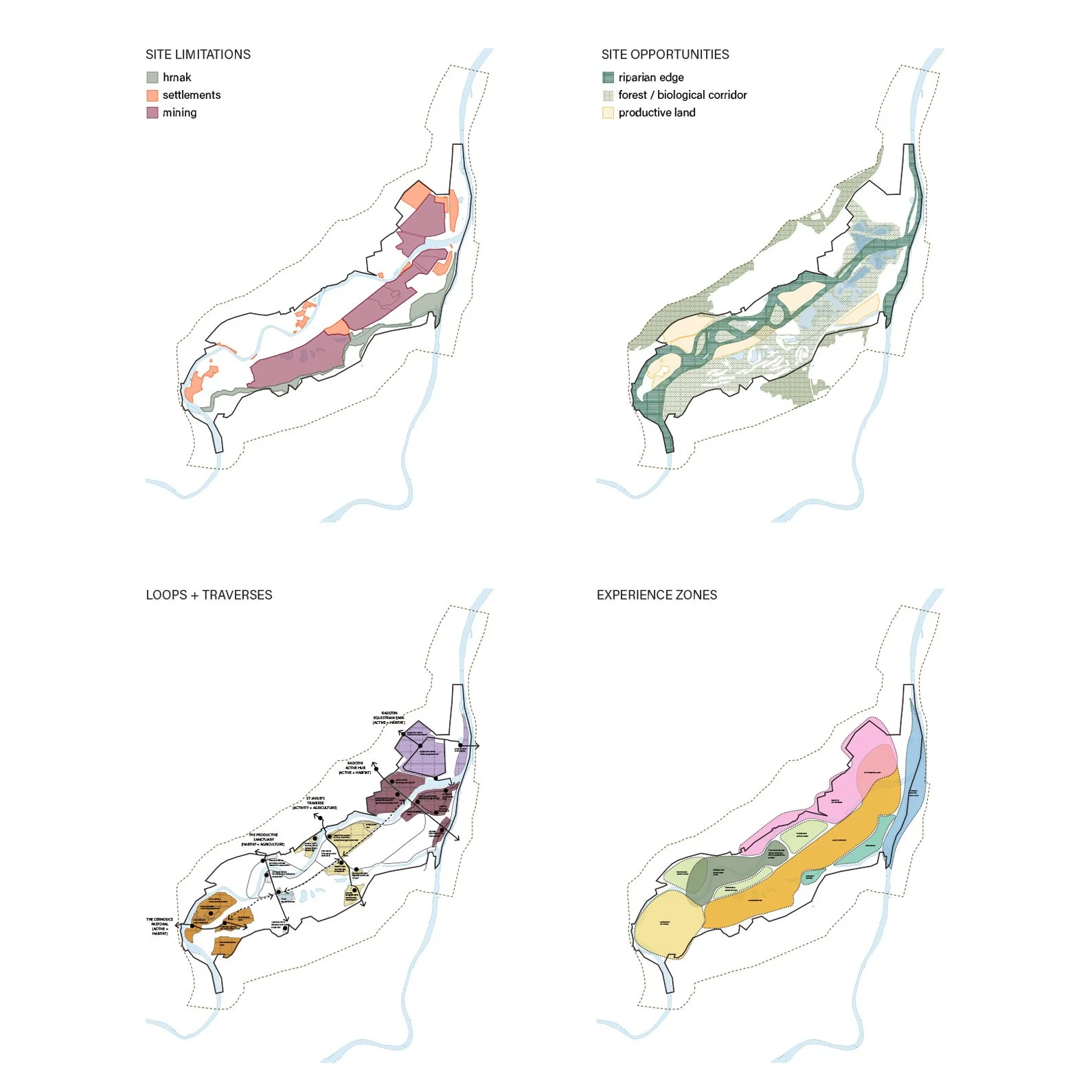
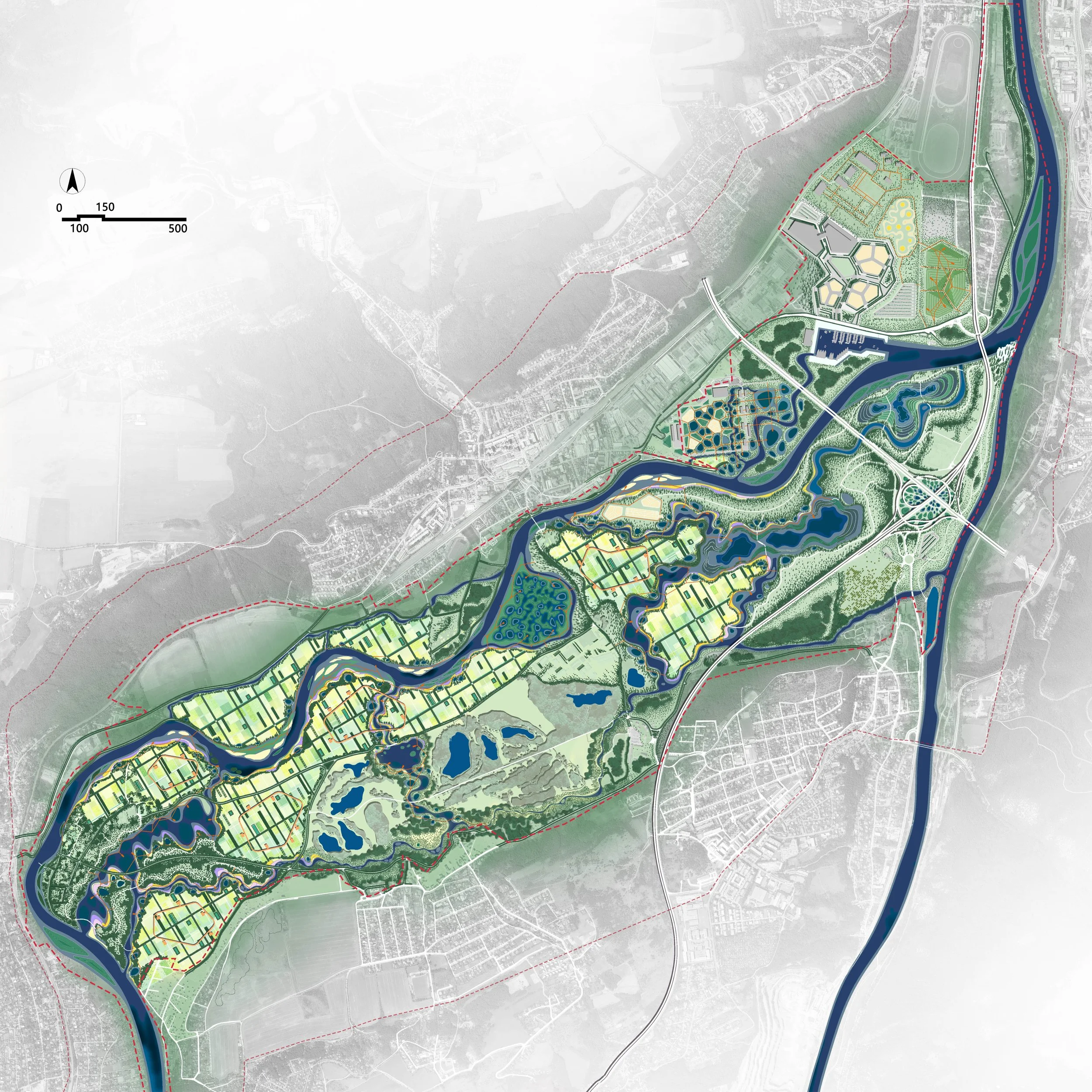
Soutok, A Productive "Sponge" Park
Suburban parks should have three functions: ecology, production and life.
In response to the challenges of frequent flooding and private ownership of land, the design proposes a new agricultural landscape model, which has three major benefits: ecological, economic and cultural.

| Location: | Czechia |
|---|---|
| Status: | Competition Finalist |
| Date: | 2022-2024 |
| With: | Turenscape / Yu Kongjian |
Suburban parks should have three functions: ecology, production and life.
In response to the challenges of frequent flooding and private ownership of land, the design proposes a new agricultural landscape model, which has three major benefits: ecological, economic and cultural.
For ecological benefits, ponds and wetlands are introduced to improve flood regulation and increase water storage capacity. When floods come, ponds can be used to receive more water, create different types of habitats, and increase local biodiversity.
For economic benefits, a variety of livelihood options are provided, in accordance with the current situation of land ownership. Gravel and sand excavated from the pits, that can become ponds, can be sold for economic profits. In the long term, the ponds can be used to raise fish and ducks or carry out water sports. The cultivated land can continue to be cultivated, or it can be used to breed livestock, plant fruit trees or operate homestays.
For cultural benefits, a recreation ring is implanted in the farmland to connect the slow rhythms of agricultural and hydrological systems with places for recreation, forming a diversified and vibrant recreation space. As a result, the existing farmland landscape on the site will gradually transition into a new agricultural model, which has both production functions and landscape recreation functions, and can regulate and store floodwaters and adapt to nature.
The above-mentioned principles of landscape change are implemented across the site. The existing golf course becomes a floodable area, and the mine pit is transformed into a large regulation pond, so as to form the final suburban park landscape according to local conditions. This is a suburban park with an ecological regulation capacity, a suburban production function and a place for cultural recreation, which will create a new model for European suburban landscape park.
The bold, neophilic character of the design reflects the character of the site itself: “a dynamic, and ever-changing, neophilic floodplain, and in it dynamic, ever-changing, neophilic suburbanization."